Pearl of East: Your travel guide in Uzbekistan.
|
Main Menu
Tashkent
Samarkand
Bukhara
Khiva
Baysun
Nukus
Margilan
Ferghana
Nurata
Namangan
Kokand
Sarmysh Say
Termez
|
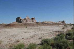
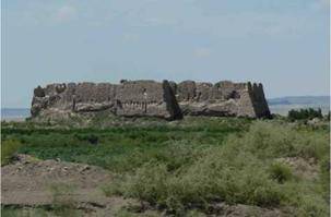
News / НовостиUzbekistan: The fortresses in the north Uzbekistan08/02/2017 20:38 In the north-west of Uzbekistan, from Khiva an excursion to the ancient fortresses in autonomous Republic of Karakalpakstan is a very attractive programme. Most of the 2000-year-old fortresses are located at the edge of the Sultan Uvays Mountain Range. Built by the people who lived in the fertile Amudarya plains most fortresses once served as defence structures from the invasions of nomadic tribes, who lived in the Kyzylkum Desert with their herds. ToprakQal'a and QizilQal'a From Khiva you will travel 100km passing Urgench, Beruniy and Bo'ston to reach ToprakQal'a. The rectangular settlement, surrounded by high fortification walls, dates back to the 2nd and 3rd century AD. The city included a palace, a temple, a residential area and gardens. The palace was built on a 9m high platform. During excavation works, men size sculptures and images of the rulers of the city and of goddesses on the walls of several halls were discovered. You can pass the nearby QizilQal'a, a small but well-preserved fortress that might have been a double-storey army base with an archers' gallery. QizilQal'a
ToprakQal'a Yurt Restaurant
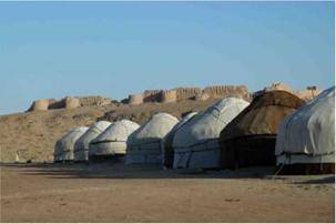
AyazQal'a and Yurt Camp
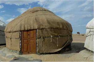
A tarred road leads to the yurt camp on top of the plateau. The camp has been set up in 1998. With financial support of UNESCO a loam winter building was erected, so that the camp is open throughout the year. Besides the building, it consists of 12 yurts which can accommodate up to 50 people on cosy, national, cotton filled kurpacha mattresses. In winter, only three yurts, equipped with ovens, remain used. Groups of up to 250 people can be catered for simultaneously. There are sanitation facilities with four toilets, three showers and two sinks. To secure the water supply in the camp, three huge water storage tanks have been installed. However, water has to be used with care, as it is very precious in the desert.
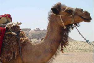
From the yurt camp, guests can go on hikes to the Qal'as, or down to the small lake Ayaz, which unfortunately has shrunk considerably in the last years, leaving a salt crust at the edges. In addition, camel rides are offered.
JonbosQal'a and Yurt Camp JonbosQal'a is located 55km north-east of To'rtkol. JonbosQal'awas most probably built as early as the 4th century BC. The double walls of the fortress are 20m high and enclose a rectangular area of 200m x 170m. From the top of the two-storeyed galleries, archers defended the fortress. Through the loopholes in the fortification walls, they could fire their arrows onto the invaders. The unique building style can be traced back to the architecture of the Assyrians and Achaemenids and was not used anywhere else in ancient Khorezm. Inside the fortress, residential buildings were erected on both sides of the central road. About 1000 people could have been housed in 150-200 rooms. At the end of the main street, the city's main fire temple was excavated.
JonbosQal'a yurt camp is located 500m uphill from the Qal'a. It offers rustic accommodation on kurpacha mattresses in six traditional yurts. Modern sanitation facilities are available. Delicious traditional dishes are served in the dining yurt. Boating or fishing on the nearby small lake can be arranged.
Gavur Qal'a
JanpikQal'a
From 10th - 14th century, JanpikQal'a was a town with residential quarters. In the 13th century, the Mongols conquered and destroyed it. After the invaders left, it was rebuilt and became a centre of craft production and trade. In different quarters of the fortress craft workshops for glassmakers, weavers, blacksmiths, potters and stone carvers had been established. Artefacts indicate that the town had a sophisticated water supply and drainage system. Many of the items found during archaeological excavations in JanpikQal'aare exhibited in the Savitskiy Museum in Nukus. These artefacts include ceramics, glassware, knitting hooks for the production of fishing nets, stoneware, bronze ornaments, jewellery, bone beads, and cowry shell necklaces. The silver and copper coins found on site indicate that JanpikQal'a must have been an important port and trading post on the Amudarya. AkshakhanQal'a
YakkeParsanQal'a YakkeParsan is a fortified manor house that was in use from the 6th to the 8th century AD. It is located 17km north-east of Bo'ston, 5km from the main Bo'ston-AyazQal'a road. Excavation works suggest that the fort must havebeen the house of one of the feudal landlords,called dihqans. There were many manor housesin the EllikQal'aarea, however, YakkeParsan isone of the few that has not been destroyed. The nobles lived in square inhabitable towers, calleddonjons, protected by fortification walls. Only remnants of the defence wall of YakkeParsanQal'aare still intact. In the area between the tower and the fortification wall, the serfs of the feudalistsresided. Local landless farmers worked for those wealthy land owners. The donjons often werelocated in such a way that the land owners had full control over the irrigation system. |
Calendar
Currency
Weather
Online Radio
 Useful Links
Searching for Airways and Hotels
|


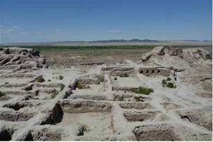 ToprakQal'a
 ToprakQal'a Yurt Restaurant
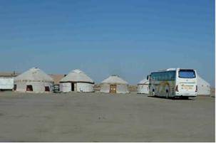
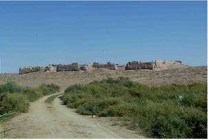
 AyazQal'a is one of the most spectacular fortresses of the region. It consists of three fortress complexes. The view from AyazQal'a onto the Kyzylkum Desert, the small lake Ayaz, the Sultan Uvays Range and the oasis is stunning. The AyazQal'a yurt camp, famous for its traditional dishes, is an ideal spot to make a lunch break or stay overnight.
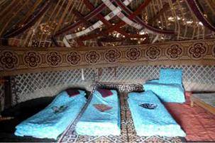
 In the outskirts of JonbosQal'a, a necropolis (burial site) was found. Burial gifts (terracotta statuettes, ceramics, jewellery) discovered here date back to the 1st century AD. Some scientists believe that the town must have been captured by nomadic tribes in the 1st century AD. Another theory suggests that the dwellers abandoned the city when the Amudarya changed its course, flooding parts of the site.
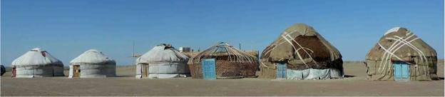
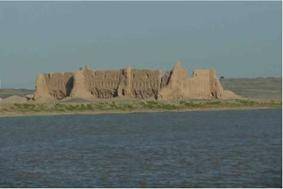 Passing the pontoon from the Khorezm side ofthe Amudarya, at Jumurtou village, GavurQal'amajestically looms on the east bank of the mightyriver. The fortress dates back to the Early Antiqueperiod (4th cent. BC - 1st cent. AD). It wasabandoned in 4th cent. AD. The northern andwestern walls of the fortress are well-preserved.The southern part has been destroyed by themeandering river. The fortress is trapezoidal inshape and had double walls with archers’ galleries. The walls were strengthened by severaltowers. The fortress guarded and controlled the important Amudarya trade route and deemed tobe a Zoroastrian place of worship at the same time. From the fortress, you can see a watch towerupstream on the escarpment.
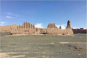 A Russian archaeologist considered JanpikQal'ato be the most beautiful fortress in Khorezm. Thefortress is located on the banks of the AmudaryaRiver at the south-western edge of the SultanUvays Mountains. You can access JanpikQal'a viaa sand road from GavurQal'a (7km) or from theNukus-Beruniy main road. The fortress waserected on the ruins of an old settlement datingback to the 4th cent. AD. The fortress itself wasbuilt in 9th-10th century AD. JanpikQal'ais irregularly shaped and protected by a double wallwith an archers’ gallery on the second floor. Five of the towers located 70m apart are still visible.
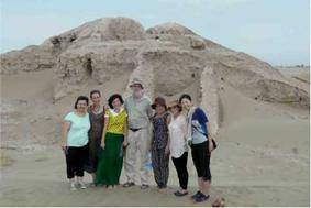 AkshakhanQal'a is located in the midst of drifting sand dunes, 16.9km north of Beruniy. With an area of 42ha, it was one of the largest fortified settlements in Ancient Khorezm. The fortress dates back to the 2nd century BC and was used until the 1st century AD. It consisted of two fortified enclosures. Traces of the monumental buildings (mausoleum, temple and palace) are still visible. The remains of the fortress are almost entirely covered with sand. Excavation works by Karakalpak and international archaeologists are still ongoing. The discovery of a portrait gallery (120 portraits) on the walls of the fortress was a sensation and proof for the existence of the semi-legendary dynasty of the Khorezm Shakhs. Since the persons depicted on the wall paintings are wearing crown shaped headdresses and gold necklaces archaeologists consider that they must have been powerful rulers. The red ears shown in some of the portraits are presumably a symbol of power and fertility. Artefacts found on site are kept at the Karakalpak Research Institute of Humanities in Nukus.